|
Saltford Environment Group
|
|
SEG Home > History of Saltford > A - Z > Walks of Saltford > Walk 7 Walk 7 - Swineford and Kelston MillsThis walk takes you out of the parish bounds, much of it on the opposite side of the River Avon, and with the opportunity to visit the historic hamlets of Swineford and Kelston Mill. This walk involves a stretch along the pavement by the busy A431, and is therefore unsuitable for smaller children.
|
Download the pdf version here
|

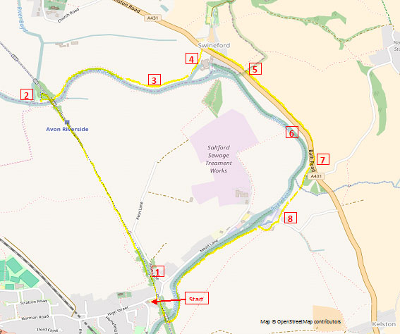
Map © OpenStreetMap contributors http://www.openstreetmap.org/copyright
|
Climb the steps from the Bird in Hand car park up to the Bristol and Bath Railway path (or go through the bridge and up the path on the other side).Walk northwards (i.e. towards Bitton and Bristol). The Bristol and Bath Railway Path was built by the cycling charity Sustrans between 1979 and 1986, which leased a five-mile (8.0 km) stretch near Saltford, with the help of the then Avon County Council, and using volunteers turned it into its first cycleway. The path follows the route of the Midland Railway Mangotsfield and Bath line, which was closed during the Beeching Axe of the 1960s in favour of the more direct former Great Western Railway between the cities. As you leave the Bird in Hand look out for the exposure of Lower Jurassic rocks on your right (1), shortly after the gated access to Avon Lane. The rocks here are approximately 190 to 200 million years old and were formed during the Sinemurian age of the Lower Jurassic period. This new exposure on the railway path (excavated in 2014/15) will link to other rock exposures in Saltford to form an accessible circular geology trail so that visitors can explore the local geology for themselves. Keep going until you reach Avon Riverside station on the Avon Valley Steam Railway. Walk past the station and over the river bridge, and then turn left down a path that leads to the picnic area (2). The small river that joins the Avon here is the River Boyd, which rises just south of Chipping Sodbury. The River Avon Trail that crosses it on Ferris Bridge - a listed structure - runs from Pill in North Somerset to Pulteney Bridge, Bath. It is a medium-distance path of about 23 miles. Walk under the railway bridge and keep going with the river on your right.
This footpath passes through several fields which formed Mickle Mead, a large area of lush meadow. After a while Avon Farm, is visible on the opposite bank of the river, and near here there used to be a horse ferry (3). In the days when river traffic was pulled by horses on the towpath, they had to be conveyed across the river where the towpath switched sides. As you approach Swineford you will see Swineford Mill on your right (4). Between 1709 and 1859 Swineford had an active brass and copper industry which were served by the river which also provided water power for the cloth industry. Swineford Mill was an early fulling mill which was adapted to roll copper sheet in 1709. By 1859 the site was sold to lead manufacturers, later converted to a flock mill and then to light engineering. Two 22ft 6ins diameter waterwheels are still in situ. Cross the busy A431 at The Swan, and turn right along the pavement. For the next 1000m or so, you will keep to this pavement. At the far end of the village on your left is the former Swineford Congregational Church (5), founded about 1887. 'Tin Tabernacles' were once a very popular, especially with the non-conformist movement, as they could be erected within days, and if the need arose, could be moved elsewhere equally quickly. Also called 'iron churches', these pre-fabricated churches saw service throughout the British Empire, where, as kits of parts, they could be shipped out and erected in a matter of days. Keep going along the A431, passing 'The Old Tannery', a small industrial unit, on your right (6). In the late nineteenth century this was the Bath & Bristol Laundry. The road then sweeps round to the right. Look out for a public footpath sign on your side of the road pointing across to the other side (7). Take this path and follow it to the little hamlet of Kelston Mills (8). Kelston Mills now houses a small marina. The furnace chimney of the old brass mill is over to your right. It and the workers' cottages date from the second half of the eighteenth century. The building of Kelston Mills is thought to have been the final expansion of one William Champion, who owned a large brass mill in Warmley, before being declared bankrupt in 1769. All the premises of his company were eventually taken over by the Bristol Brass Co. It is thought that the mill ceased operating in about 1840. Keep going straight on and walk in front of the row of cottages and over a stile into a field. Follow the path towards the river and then follow it along the river bank, with views over to Saltford Lock, The Jolly Sailor, and the houses along Mead Lane. Keep going until you reach the Bristol and Bath Railway Path again. Climb up the steps and turn right to return to The Bird in Hand. Written by Andrew Stainer (2016) © Saltford Environment Group
|


