|
Saltford Environment Group
|
|
SEG Home > History of Saltford > A - Z > Walks of Saltford > Walk 4 Walk 4 - Manor Road Community Woodland and an old road to KeynshamPlease note that some of this walk is temporarily inaccessible whilst new housing is being constructed in East Keynsham. This easy walk explores part of the boundary between Saltford and Keynsham parishes, following an ancient pathway that was probably the predecessor to the A4, and passing through Manor Road Community Woodland.
|
Download the pdf version here
|

Map © OpenStreetMap contributors http://www.openstreetmap.org/copyright
|
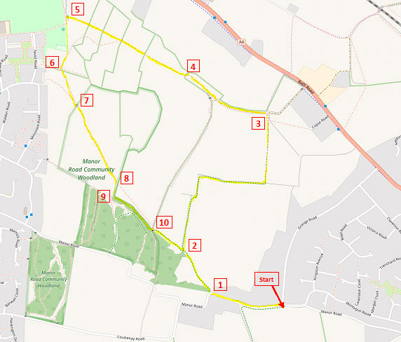
Head off along the narrow section of Manor Road after the junction with Grange Road, past Keynsham Manor, to the sharp left-hand bend, where you turn right through a gate onto a footpath (1). The roads in the Saltford area have undergone various name changes in the past. The 1861 Census calls Manor Road 'Burnett Lane', as it led, via what we now know as Longwood Lane, to the village of Burnett. On the 1888 Ordnance Survey map, Grange Road was called 'Boyd Lane', which was also the earlier name of Norman Road. And the same map calls this part of Manor Road that you are walking along, 'Field Lane'. Keynsham Manor - now divided into two dwellings - is a Grade II listed building dating from the late 18th Century. An early map from about 1830 calls it 'The Cottage'. The footpath heads off diagonally left, keeping close to the wood on your left. This footpath is a Permissive Path, a path whose use is allowed by the landowner. The Permissive Paths to the south and west of Saltford were closed in 2013 following the withdrawal of subsidies for public access by DEFRA. The Saltford Community Association has worked with the local farmer and have signed a legal agreement allowing access to 4.5Km of these paths. In order for these paths to remain open the SCA needs to raise specific donations of £3000 every year. You can make a donation at this link or by contacting the SCA at Saltford Hall (www.saltfordhall.co.uk). When you reach the first hedgerow turn sharp right (2), keeping it on your left, and follow down the side of the field. Follow the hedgerow round to the right, and then turn left down a concrete track. When the track turns sharp right, turn sharp left instead along a field path (3). This straight path goes through a small wooded area and then emerges in another field at a kissing gate (4). Go straight across the field towards another kissing gate. Keep going, passing through 3 further kissing gates. This field path is an old trackway that was possibly the original link between Bath/Saltford and Keynsham. Before the building of Wellsway School and the houses near it, the track headed straight through to Chew Bridge, and then up Dapps Hill and Temple Street into Keynsham. This is a more direct route than the current route along the A4, but the drop down to the River Chew and subsequent climb on the other side would have been difficult for wheeled vehicles, prompting the development of the easier route along the Bath Road into Keynsham. After the last kissing gate, walk straight across the field to the wooded area, and turn left before the path goes through the gate into the wood (5). Head up the field to where it narrows between two hedgerows, and then go slightly diagonally right towards a gap in the hedgerow leading to the next field (6). Go diagonally left towards the woodland, and cross the footbridge (7). You are now in Manor Road Community Woodland. This is a new broadleaved woodland planted at stages between 1993 and 2006 by local people, voluntary groups and local contractors. The site is owned by Bath & North East Somerset Council and has full public access. Also it has been designated as a Local Nature Reserve. The woodland covers an area of some 15 hectares (37 acres) and is well used by the surrounding community. The 'Friends of Manor Road Community Woodland' meet on a regular basis to keep up community involvement and further development of the site. See their Facebook page https://www.facebook.com/fmrcw/
Keep straight on and cross the meadow diagonally. At the far side (8) turn right and then immediately left (9) along the inside edge of the woodland, with the hedgerow on your left. (If you have time you may wish to explore the many paths that wind their way through the woodland). After about 200m you will see an exit from the woodland on you left (10). Go out, and turn immediately right along the edge of the woodland. You will soon come to the point where you started the walk. Written by Andrew Stainer (2016) © Saltford Environment Group
|


